
The dust of the Sahara Desert reaches astonishing levels in the Atlantic Ocean. What does this mean for hurricane season?
First, Europe was hit by record dust flying in from the Sahara Desert in Africa. However, the Atlantic Ocean seems to have taken the lead, and in parts of the Sahara Desert basin, a level of dust not seen in the past few years has been generated.
According to satellite observations, dust eruptions called the Sahara Desert air layer are concentrated in most of the eastern Atlantic Ocean. Traces of dust have traveled more than 4,000 miles to Florida and the Gulf Coast.
Particles scattered typical colors, and since orange, yellow, and red colors dominated the sky, sunrises and sunsets became more vivid throughout the Sunshine State.
In addition to the bright colors, there are also things that don't fall from the sky.
According to NOAA (National Oceanic and Atmospheric Administration), the atmosphere surrounding SAL (Saharan Air Layer) contains about 50% less moisture than the normal atmosphere. In other words, there is a possibility that the presence of SAL will adversely affect cloud formation and thunderstorm activity.
During the first few months of hurricane season, large plumes of dust and dry air are generated, and usually last until mid-August.
Reflections on phenomena that could disrupt the active hurricane season
NOAA estimates that more than 0.1 billion 80 million tons of dust leave the African continent each year, reducing the formation of thunderstorms and tropical cyclones.
Dry air and the dust of the Sahara Desert are eternal wild cards that influence the outlook for tropical weather.
Cyclone activity often declines in years when there is a lot of dust. The season with minimal dust is usually at the top of activity because the amount of water available to tropical systems increases and water temperatures rise.
Since water temperatures have risen in most parts of the basin this season, the effects of sandstorms have remained minor.
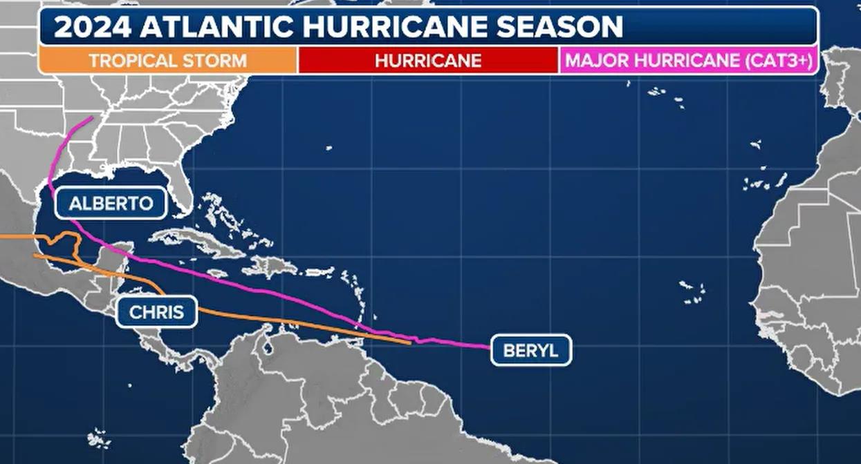
Exposure to warm seawater and limited dry air helped form Albert, Beryl, and Chris from late June to early July.
Since Beryl's historic trek through the Caribbean Sea into the Gulf of Mexico, the basin has been relatively quiet.
The trend of limited activity in the Atlantic basin is expected to continue for the foreseeable future, and the next cyclone may be weeks away.
In an average year, the fourth storm usually doesn't occur until around August 15.
Despite adverse conditions in the Atlantic Ocean, hurricane forecasters at Colorado State University say 2024 will be a busy season in the Atlantic.

The CSU announced the latest forecast on Tuesday, and says 22 more storms, 11 hurricanes, and 5 major hurricanes will occur.
“This forecast is more reliable than normal. The CSU forecaster said in the latest tropical update, “We anticipate that the probability of a major hurricane landing on the American coast and the Caribbean will be well above average. “As with all hurricane seasons, coastal residents can be reminded that just one hurricane makes it an active season.
The season runs until November 30, but nearly 60% of cyclone formation occurs in August and September.

Disclaimer: Community is offered by Moomoo Technologies Inc. and is for educational purposes only.
Read more


Comment
Sign in to post a comment
